
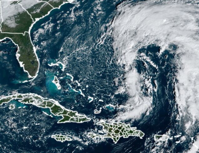
(Bloomberg) — Subtropical Storm Nicole is forecast to come ashore in southeastern Florida as a Category 1 hurricane later this week, bringing a surge of water and flooding rains, including to areas still recovering from Hurricane Ian.
Nicole, with top winds of 45 miles (72 kilometers) per hour, is about 495 miles east of the Bahamas in the Atlantic, the US National Hurricane Center said in an 11 a.m.
New York time advisory. The storm is forecast to gain strength as it nears Florida, reaching the first rung on the five-step Saffir-Simpson scale with winds of 75 mph just before landfall, and will then move up the US seaboard.
A hurricane watch has been issued for the northwestern Bahamas and Florida’s east coast from the Volusia-Brevard County line to Hallandale Beach just north of Miami, as well as for Lake Okeechobee.
“Hurricane conditions are possible within the watch area in Florida by Wednesday night,” according to Philippe Papin and Daniel Brown, forecasters at the center.
While the track could change, the current forecast has the storm coming ashore somewhere between West Palm Beach and Fort Lauderdale, a stretch that includes former President Donald Trump’s Mar-a-Lago estate, according to Brandon Buckingham, a meteorologist with commercial forecaster AccuWeather Inc.
Read more: Tracking substropical storm Nicole’s latest path
Nicole is the 14th named storm of the Atlantic season, which has also produced Hurricane Fiona, a system that devastated Puerto Rico and the Canadian Maritimes, as well as Ian, which ripped across Florida killing at least 140 people and causing massive damage.
Florida is the largest-US producer of orange juice. Both storms hit in September.
While the storm is unlikely to significantly damage orange trees, it could cause fruit to drop to the ground, according to World Weather Inc. President Drew Lerner. Orange juice futures rose as much as 2.9% Monday on the ICE Futures US exchange.
Read More: Storm May Harm Florida’s Citrus Crop, Sugarcane
Nicole’s designation as a subtropical storm doesn’t mean it’s any less powerful than a tropical one.
Rather, it has to do with how the storm is organized and fueled.
A tropical system has its most powerful winds at its core and gets its power from warm ocean water. A subtropical one can have its strongest winds far from its center. It derives its strength, meanwhile, from differences in temperature and air pressure.
“It doesn’t change the net effects of the storm,” Buckingham said.
In some ways, that hybrid structure could actually make Nicole more destructive.
Its tropical-storm strength winds currently reach out 275 miles from its center and “will likely cause significant wind, storm surge, and rainfall impacts over a large portion of the northeastern Bahamas, Florida, and the southeastern coast of the US during much of the upcoming week,” Papin and Brown wrote.
As it hits land, Nicole could push upwards to 5 feet (1.5 meters) of water on shore along parts of the Florida coast.
The Atlantic hurricane season got off to a slow start, but has now reached the long-term average of 14 storms and hit the bottom of the National Oceanic and Atmospheric Administration’s preseason forecast spread.
Nicole will cross very warm water in the Bahamas, which could help it strengthen, Buckingham said.
Heavy rains across Florida could bring another round of flooding, particularly along the St. John’s River, which is still at flood stage following Hurricane Ian, according to the National Weather Service.
After Florida, Nicole is forecast to drag heavy rain up the US East Coast, Buckingham said.
–With assistance from Marvin G. Perez.
More stories like this are available on bloomberg.com
©2022 Bloomberg L.
P.